Composite Analysis of the RR3 Parcel
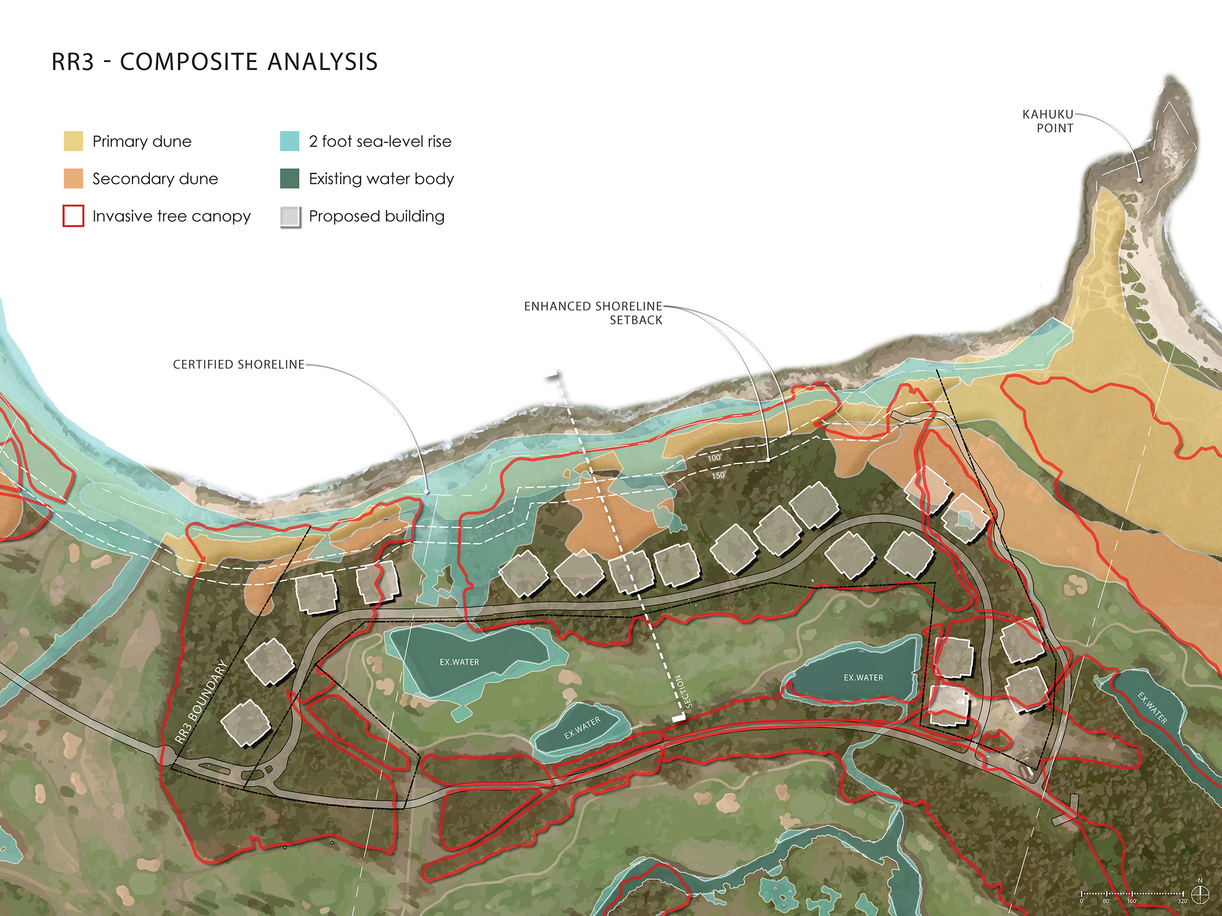
The composite analysis visual showcases how Areté Collective determined the building sites for the project on parcel RR3. The thorough analysis identified the most suitable development locations by mapping sensitive areas, existing features, and other constraints. Ensuring compliance with all requirements while conserving and restoring the dune structure to encourage wildlife return, and sustainability is our top priority.
The RR3 analysis involved assessing the locations of invasive forests, primarily Ironwood trees, primary and secondary dune formations, and the potential impacts of a two feet of sea level rise over 40 years, and wave hazard inundation on the property. The plan also outlines the property boundaries and required setbacks. Buildings will be set back 150 to 350 feet from the shoreline, and 70% of the land will be preserved as open space.
By creating this composite plan, the Areté team gained a clear understanding of the most suitable areas for roadways and building sites, as well as where the public access trails will be. Areté has also ensured that view corridors are maintained and that building heights remain well below the 90-foot limit.
Areté Collective continues to analyze the land to guide responsible development. For specific questions, please contact us.
Recent News
Development Update October 2025
A temporary dust fence is being installed along Kaihalulu East Drive for 18–24 months to protect the environment and the construction area. Irrigation mainline realignment between holes 10 & 18 on the Fazio golf course continues with completion by the end of August. Mauka Basin work begins. Foundational work on RR3 phase 1 continues. Public access to hiking and biking trails will remain open throughout construction, with temporary access available via the Kahuku Trail
Development Update September 2025
A temporary dust fence is being installed along Kaihalulu East Drive for 18–24 months to protect the environment and the construction area. Irrigation mainline realignment between holes 10 & 18 on the Fazio golf course continues with completion by the end of August. Mauka Basin work begins. Foundational work on RR3 phase 1 continues. Public access to hiking and biking trails will remain open throughout construction, with temporary access available via the Kahuku Trail
Areté Collective begins construction on Turtle Bay development following delays
Areté Collective purchased 65 acres on Oahu’s North Shore for $43 million last year from Blackstone, planning a high-end development next to The Ritz-Carlton Oahu, Turtle Bay resort. The project will eventually include 100 resort residential units and up to 250 hotel units in coming years.


